|
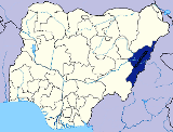
PROFILE Adamawa State has a total area of 39,742.12 square kilometers. This is about 4.4 percent of the land area of Nigeria. LOCATION The State lies between latitudes 80 N and 110 N longitude 11.50 E and 13.50E. POPULATION The projected population of the state for 2005 is 3,106,585, given population density of 68 persons per square kilometer. The 1991 provisional Census figure of the state was 2,124,040. THE PEOPLE Adamawa State has a large number of ethnic groups who live in segmented communities speaking different languages and dialects, while English remains an official language. Hausa and Fulfulde are widely spoken throughout the state. OCCUPATION Majority of the people in Adamawa State are farmers. Crops produced include Groundnut, Cotton, Maize, Yam, Cassava, Guinea Corn, Millet, Beans, Sweet Potato and Rice. Cattle rearing are a major occupation, while village communities living on the banks of River Gongola and Benue in the State engage in fishing and dry season production of vegetable crops like tomato, onion, pepper, amaranthus, okra, garden egg and melon using wash bore and tube well irrigation with water pumps. Much of these Fadama crops are in abundance during the dry season and are transported out to neighbouring States because of its availability which makes the State a major producer of these crops. RELIGION The main religions are Christianity, Islam and Traditional Religion. |
|
||||||||||||||||||||||||||||||||||||||
|
CULTURAL HERITAGE
Adamawa State is noted for its cultural heritage which is reflected in its craftsmanship, music and dances, dress patterns, the peoples hospitality and cordial inter-relationship. TOPOGRAPHY
The State essentially has picturesque mountains, and land traversed by big River valleys of Benue, Gongola and Yedsarem. The valleys of Cameroon, Mandara and Adamawa mountains form part of this undulating landscape. CLIMATE The State has tropical climate marked by dry and rainy seasons. The rainy season commences in April and ends late October. The average rainfall for the state is 79mm in the northern parts and 197mm in the southern parts especially around Ganye Local Government Area. The wettest months are August and September. The dry season starts in November and ends in April. There is also the harmattan period when the dust-laden North-Easterly Trade winds from the Sahara-Desert have a marked effect on the climate of the state. The period is cold and dry. Temperatures vary from place to place but the average recorded minimun temperature is 15.20C the maximum is 39.70C. VEGETATION There are two notable vegetation zones within the state, the Sub-Sudan zone and the Northern Guinea Savannah zone. The Sub-Sudan zone is marked by short grasses and short trees, commonly found in the Northern parts of the State. To the South, the vegetation is thick with tall grasses and trees. ADMINISTRATIVE SET-UP There are 21 Local Government Councils and 37 Development Areas in the State |
|||||||||||||||||||||||||||||||||||||||