|
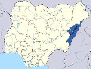
Adamawa is a state in northeastern Nigeria, with its capital at Yola. It was formed in 1991 from part of Gongola State with four administrative divisions namely: Adamawa, Ganye, Mubi and Numan. It is one of the thirty-six (36) States which constitute the Federal Republic of Nigeria. Major towns are Yola, Mubi, Ganye, Numan, Guyuk, Michika, Mayo-Belwa, Gombi and Jimeta. |
|
Adamawa is one of the largest states and occupies about 36,917 square kilometres. It is bordered by the states of Borno to the northwest, Gombe to the west and Taraba to the southwest. Its eastern border also forms the national eastern border with Cameroon. Topographically, it is a mountainous land crossed by the large river valleys - Benue, Gongola and Yedsarem. The valleys of Cameroon, Mandara and Adamawa mountains form part of the landscape.
The major occupation of the people is farming as reflected in their two notable vegetational zones, tile Sub-Sudan and Northern Guinea Savannah Zone. Their cash crops are cotton and groundnuts while food crops include maize, yam, cassava, guinea corn, millet and rice. The village communities living on the banks of the rivers engage in fishing while the Fulanis are cattle rearers. The state has network of roads linking all parts of the country.The development of many communities in the State can be traced to the colonial era when the Germans ruled the Ganye area in the 19th century. These were however forfeited to the British at the end of the scramble for Africa at the Berlin.A visit to the state will not be complete without going to Mubi. Mubi's weather is very accommodating for human confort. A visit to Nuhu Auwalu Wakili's Palace will keep your memory of the state at all times. No wonder the state is some time known as "the land of beauty".
|
The Physical Setting Adamawa State lies between latitudes 70 281-100 561 N and longitudes 110 301 - 130 751E. It is bounded to the North by Borno State, to the north - west by Gombe State, to the southby Taraba State and to the east by the Republic of Cameroon with which it has its longest border of about 492 km. With a total areal extent of about 42, 159 km2. Adamawa State has some of the longest mountain ranges and breath -taking landscape sceneries in the country with areas as low as about 129 metres and as high as 2042metres above sea level. The land rises from the low-lying Gongola and Benue valleys to the rugged hills to the north, north-east defining the Mandara, Alantika and Shebshi Mountain ranges and the central portion, which is dotted with isolated uplifts such as the Lamurde Longuda, Song -Bagale and Yardang hills, etc. The climatic type is that of the Tropical Continental North characterised by the Sudan Savannah Zones and the Tropical Hinterland represented by the Northern and Southern Guinea Zones. There are two distinct seasons, the wet season, which starts from April to October and the dry season from November to April. The mean annual rainfall for the Savannah zones in the North is between 750- 850mm and 14001600mm for the Guinea zones in the South. The wettest months are July - August while the driest periods, are March -May. The mean annual Temperature is 27° -28°c in the Savannah and 18 -27°c for the Guinea Zones. The aridity index for the Savannah is about 2 and 1-1.6 for the Guinea zone. Temperatures of up 43°c have been recorded during March -May.There are two major vegetation zones and correspond with the climatic types, - the Sudan and sub-sudan vegetation zone in the North typified by short grasses, trees, shrubs, etc. and the Guinea zones to the south defined by thick vegetation cover, tall grasses and trees. The Human Environment The 1991 population figure for the State was 2,124,049 but the current figure is about 3.6million. There are more than 60 ethnic groups with different languages in the State and main ones include Marghi, Higgi, kilba, Bura, Hausa, Fulani, Bwatiye, Chamba, Longuda, Yungur, Kanakuru, Gude, Fali, Lala, and others. Agriculture is the primary activity of the people and crops grown include maize, groundnuts, rice, guinea corn, yams, cassava and vegetables. The main secondary activities include irrigated agriculture, transportation, medium and small-scale industrial set-ups, education, fishing, cattle rearing and the commercially based, petty trading. The State has several educational institutions – secondary schools, technical colleges, Colleges of Education, State and Federal Universities and private institutions. There are more than 10 different commercial institutions including the CBN and the Nigerian Stock Exchange which assist financially for industrial and commercial activities. There are four media houses, - the ABC, ATV, FRCN and the NTA. Radio Gotel Ltd. is expected to hit the airwaves soon. There is an International Airport and an NNPC Depot at Yola, the capital. There are more than 40 different hotels in the state capital some of which are of International standard that offer first class services, such as the Yola Int. Hotel and Chembian Heritage. |